(Note: This story has been updated. Please click here.)
Long considered the “crown jewel” of the California State Park system, Point Lobos State Natural Reserve is a magnet for nature lovers the world around. From its breathtaking beauty to its fascinating wildlife to its friendly and knowledgeable volunteers, Point Lobos is a place where one can escape to the serenity of nature at its best.
Most visitors to Point Lobos are on foot. What many don’t realize is that some of the most beautiful landscapes within the Reserve are found underwater. While the Reserve hosts 550 fully protected land acres, its protected underwater area is over eighteen times that size, at 9,907 acres.
In 1960, the first 750 underwater acres were added to the existing land area within Point Lobos State Natural Reserve, creating the first marine reserve in the State of California and the second in the United States. Its fifty-plus years of protected status and limited access have allowed the marine life to flourish, without interference, among stunning natural surroundings such as steep walls, giant kelp forests, and granite reefs.
Until now, the only way to experience the underwater landscape of the Point Lobos State Marine Reserve has been to secure one of 30 permits issued each day to proficient divers. Even then, without the guidance of someone extremely familiar with the territory, you’d be unlikely to know where you have been while seeing the extraordinary kelp forests, schools of fish, and friendly seals.
Imagine knife-edge structures as tall as skyscrapers; giant pinnacles undamaged by the erosion of their land-based counterparts; chasms barely wide enough to swim through; ledges dropping into unfathomable depths; topography that was above water during the last ice age, preserved much as it might have looked thousands of years ago when humans first camped on this shore.
Thanks to the efforts of some dedicated members of the Bay Area Underwater Explorers (BAUE) and support from the community, visitors to Point Lobos will soon be able to visualize the undersea world—without getting wet. A permanent, museum-quality 3D model of the underwater park has been installed at Whalers Cove and will be unveiled to the public on Saturday, May 10, 2014.
With this model, divers will finally be able to picture the underwater topography so they can navigate their way to points of interest. And non-diving visitors will surely gain a greater appreciation for the mysterious realm below the waters, making them more likely to support efforts to preserve and protect this extraordinary treasure.
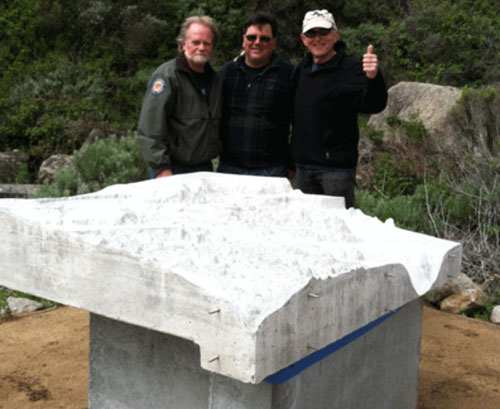
Gary Banta (on right) and friends after successfully installing the new 3D model.
Creating a “Must-See” Model for a Must-See Location
Creating a museum-quality 3D model of the Point Lobos State Marine Reserve was no simple task. Years in the making, the project began with improving on existing maps which were fuzzy, inaccurate, and incomplete, and not helpful for visualizing what was below the waves.
In 2010 BAUE began a project to fill the gaps in the mapping data. More than two dozen BAUE divers spent three days braving 44-degree water in a difficult, painstaking manual process of mapping a section of the ocean floor, using knotted and numbered lines to coordinate depth measurements in a grid pattern. They successfully mapped a rectangular section of the underwater topography.
This manual approach, however, was impractical for the entire expanse of the underwater reserve. So BAUE member Gary Banta raised money to fund the use of the California State University at Monterey Bay’s (CSUMB) Kelpfly, a jet-ski-based, multi-beam sonar platform, to map the entire undersea area at a 1-meter resolution. The resulting high-resolution data set led to unprecedented levels of accuracy and detail within the 3D underwater model.
“I am so pleased that we have now developed the tools that will help the visitors to Point Lobos and the dive community to discover the majestic wonders found within the Point Lobos State Marine Reserve,” said Gary Banta. “This protected reserve offers one of the richest marine habitats in California and stunning underwater structures. My hope is that this model will be a ‘window’ to this stunning Reserve, allowing generations of visitors to experience its wonders.”
Investing his own time and expertise, as well as additional contributions, Banta used a CNC (computer numerical control) machine to carve the shape of the underwater topography to create a master, from which the final 800 pound concrete model was cast. To complement the 3D model, Banta also developed an interpretative sign for park visitors and detailed maps for distribution.
Please check back next week for an update after the public unveiling this weekend!