For divers familiar with the Monterey Bay area, Point Lobos is a hotspot for recreational diving, known for its large and diverse fish populations, rugged underwater topography and unspoiled scenery. Located just south of Carmel, the area has been called the “greatest meeting of land and water in the world.
Like Monterey Canyon to the north, the Carmel submarine canyon provides cold, nutrient-rich water to the surface during upwelling events which feed large and very diverse range of life. Easy access for divers is available here and limited to just 30 permits per day from the Point Lobos website.
Due to its status as a marine reserve, diving here is pristine and unspoiled. While the Reserve hosts 550 fully protected land acres, its protected underwater area is over eighteen times that size, at 9,907 acres.
Until now, divers could only explore small areas of the underwater park on each dive. Without the guidance of someone extremely familiar with the territory, you’d be unlikely to know where you have been while seeing the extraordinary kelp forests, schools of fish, and friendly seals.
Thanks to the efforts of the Bay Area Underwater Explorers (BAUE) and support from the community, visitors to Point Lobos are now able to visualize the undersea world without getting wet. A permanent, museum-quality 3D model of the underwater park has been installed at Whalers Cove and was unveiled to the public on May 10, 2014.
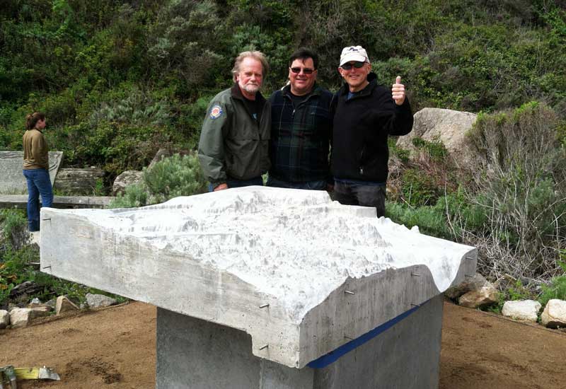
Greg Palermo, State Parks; Mike Donovan, Central Concrete; and Gary Banta
Years in the making, the project began with improving on existing maps which were fuzzy, inaccurate, and incomplete, and not helpful for visualizing what was below the waves.
In 2010 BAUE began a project to fill the gaps in the mapping data. More than two dozen BAUE divers spent three days braving 44-degree water in a difficult, painstaking manual process of mapping a section of the ocean floor, using knotted and numbered lines to coordinate depth measurements in a grid pattern. They successfully mapped a rectangular section of the underwater topography.
This manual approach, however, was impractical for the entire expanse of the underwater reserve. So BAUE member Gary Banta raised money to fund the use of the California State University at Monterey Bay’s (CSUMB) Kelpfly, a jet-ski-based, multi-beam sonar platform, to map the entire undersea area at a 1-meter resolution. The resulting high-resolution data set led to unprecedented levels of accuracy and detail within the 3D underwater model.
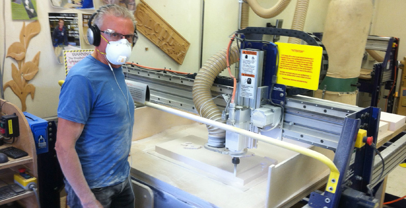
Gary Banta at the CNC Machine, creating the model.
“I am so pleased that we have now developed the tools that will help the visitors to Point Lobos and the dive community to discover the majestic wonders found within the Point Lobos State Marine Reserve,” said Gary Banta. “This protected reserve offers one of the richest marine habitats in California and stunning underwater structures. My hope is that this model will be a ‘window’ to this stunning Reserve, allowing generations of visitors to experience its wonders.”
————————————————————————————————————————————-
Be sure to read:
Shore Diving Monterey: Exploring Point Lobos State Reserve
Beyond the Cove: Mono Lobo’s Diversity Awaits
————————————————————————————————————————————-
Investing his own time and expertise, as well as additional contributions, Banta used a CNC (computer numerical control) machine to carve the shape of the underwater topography to create a master, from which the final 800 pound concrete model was cast. To complement the 3D model, Banta also developed an interpretative sign for park visitors and detailed maps for distribution.
The display is now on permanent display at Point Lobos and available for everyone – divers and non-divers – to explore the underwater world at Point Lobos.